TABLE OF CONTENTS
Sign-Up
Enter your email address
Are you frustrated with inefficient route planning? Automated GPS route planning software is the solution you need to save both time and money.
You probably don’t know but—the market for GPS tracking devices is very likely to grow with time. This increase is due to the rising demand for location-based services and the widespread use of GPS-enabled mobile devices.
Many businesses are using GPS route planning software because of its growing trend. But what exactly is GPS route planning, and how can it help your business succeed? Continue reading to know all about it.
What is GPS Route Planning?
GPS route planning is the process of determining the most efficient and optimal route between two or more locations by using GPS technology. It involves the use of specialized software or applications that utilize GPS data, maps, and algorithms to calculate the best route based on various factors such as distance, travel time, traffic conditions, and user preferences.
GPS route planning software generally includes features such as:
- Step-by-step directions
- Real-time traffic updates
- Estimated time of arrival (ETA) calculations
- Alternate route suggestions
- Fuel-efficient or eco-friendly routing options
- Customizable preferences (e.g., avoiding tolls, highways, or ferries)
In simple, GPS route planning helps users navigate more efficiently, reduce travel time, and minimize fuel consumption and costs. It happens through accurate and up-to-date information about the road network and traffic conditions.
How Does GPS Route Planning Work?
GPS route planning relies on GPS technology, mapping data, and advanced algorithms to determine the optimal route. Here's a general overview of how it works:
- GPS data collection- GPS satellites continuously transmit signals that are received by GPS receivers in vehicles, smartphones, or dedicated GPS devices. These receivers use the signals to determine their precise location, speed, and direction of travel.
- Mapping data- The GPS route planning software utilizes detailed mapping data that includes information about roads, highways, traffic patterns, and points of interest. This data is typically obtained from various sources, such as government agencies, commercial map providers, and crowdsourcing platforms.
- Route calculation- When a user inputs their starting point and destination, the GPS route planning software uses algorithms to analyze the mapping data and calculate the optimal route. These algorithms take into account factors such as distance, travel time, traffic conditions, road restrictions, and user preferences to determine the most efficient path.
- Real-time traffic updates- Many GPS route planning systems incorporate real-time traffic data from various sources, such as government agencies, traffic monitoring systems, and crowdsourced data from users. This information is used to adjust the route and provide accurate ETAs, as well as suggest alternate routes in case of traffic congestion or unexpected delays.
- Step-by-step directions- This planning software also provides turn-by-turn directions to the user once the optimal route is calculated which guides them through the journey. These directions are commonly displayed on a map or as text instructions and may include voice-guided navigation for hands-free use.
Applications of GPS Route Planning
Indeed, GPS route planning is crucial for delivery and logistics companies. It helps optimize routes, reduce travel time, and minimize fuel costs. Real-time traffic updates and efficient routing ensure timely deliveries and enhance customer satisfaction.
Companies with fleets of vehicles use GPS route planning to monitor locations and track performance. It improves scheduling, reduces idle time, and boosts productivity.
Even the emergency services rely on GPS route planning to reach quickly at emergency locations. They can avoid traffic and reach destinations faster which is essential in urgent situations.
Notably, personal use apps on smartphones operate GPS route planning to provide step-by-step directions and traffic updates. They help users to reach unfamiliar areas more easily.
Field service companies use GPS route planning to optimize routes for technicians. It allows them to complete more jobs each day and improves overall efficiency and service.
Public transportation systems benefit from GPS route planning by optimizing routes and schedules. Real-time tracking of buses and trains offers accurate arrival times and service updates.
Interestingly, some of outdoor enthusiasts use GPS route planning for hiking, biking, and road trips. It helps them find the best paths and avoid getting lost.
Farmers utilize GPS for precision agriculture. It allows for planning efficient routes for equipment and optimizing field operations which leads to increased yields and reduced costs.
Bottom Line
GPS technology is crucial for improving access to anywhere which is proven as many people and businesses use it, like delivery services, emergency responders, public transport, personal trips, or outdoor activities. We can say it optimizes travel by improving route planning which helps to save time and money while enhancing efficiency.

Aiden mitchell
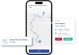
As a GPS Tech geek, I find Lumyri's transformative impact on GPS technology on businesses and their customers. Real-time tracking information empowers businesses to provide accurate delivery estimates, allowing customers to plan their schedules with precision.


