
What is Precision Agriculture?
Precision agriculture is a crop management concept that utilizes GPS technology to ensure that crops and soil receive exactly what they need for optimum health and productivity. When you use GPS, it efficiently manages your resources. Rather than administering the same treatment to an entire field, you apply fertilizer, water, and pesticides in the exact amount where it is needed.
You can gather a detailed information by using GPS agriculture software. You can monitor soil conditions, track the health of crops, and keep yourself updated on weather patterns. It is a data-driven approach to make wise decisions. Precision agriculture increases farmer yields while simultaneously reducing waste. This targeted method does not only save resources but also promotes a more sustainable way of farming. In addition, it also helps the environment and helps the farmer's bottom line.
How does precision agriculture work?
The farmers are now enlightened about this modern technology. They realize that its amazing potential can increase the productivity of their work, so they're modernizing it. They have begun with a detailed mapping of their fields. Using high-resolution maps helps them to understand soil variations, crop conditions, and other factors affecting productivity. So, they precisely guide how to plant, irrigate, and fertilize their crops. This way, every section of the field gets the right treatment.
And then there's tractor GPS guidance. GPS-enabled huge agricultural machines like tractors, harvesters, and sprayers will go with stunning precision. It helps eliminate overlap and misses. As a result, waste is minimized due to great work precision, resulting in high yields of better crops.
The story gets better since other functionalities entail real-time tracking; as in real-time data and remote monitoring where it provides live data regarding the current condition of the crop's health as well as the environmental state. Through this instant information, you are able to intervene in time in case of problems before they degenerate and lead to the improvement of the total overall management of the farm.
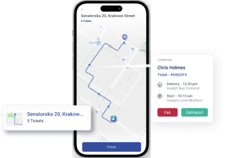
What are the Core Benefits of Agriculture GPS Tracking Software?
Agriculture GPS Tracking Software helps you to track heavy equipment and agriculture machinery. It provides real-time data that allows making an informed decision. It requires no installation of additional hardware since you can trace all through the cloud-based solution; it is available at any point in time.
Farm Equipment Tracking
Farm Equipment Tracking Track heavy farm equipment even in far-off rural regions with geo-location capability. This ability gives them the opportunity to undertake activity planning and execution using real-time location information. This minimizes downtime and increases efficiency. Equipment tracking helps alert you to unexpected problems. This way, you are able to respond very fast to any problems in the field. Minimize idle time and maintain appropriate deployment of machinery.
Through GPS tracking farm equipment, you are able to maintain your machinery by establishing usage patterns. Timely maintenance can be scheduled based on actual usage rather than estimates, extending the life of the equipment and reducing repair costs. This proactive approach aids in increasing general farm productivity. The GPS farm equipment tracking also helps in taking care of the equipment. When you manage maintenance timely, it increases equipment life. Furthermore, it brings down the cost of repair.
Remote Field Management
Another significant advantage of agriculture GPS tracking is enhancing remote field management efficiency. You will be able to trace the movement of machinery and routes followed, which enhances field and crop operations. The remote management capacity assures that every part of the field receives due attention without continuous physical presence. This can, therefore, mean that quite a number of fields can be monitored from a single site. It only needs to alert you on time to avert the occurring issues, such as equipment failure or off-route position. Such a technique of monitoring and managing fields remotely is evidence of efficiency and effectiveness in farm operations. Further, the White label GPS Tracking platform improves resource allocation. Farmers can optimize operations based on real-time data. This improves overall field management and crop yield.
Asset Safety and Tracking
You can better ensure the safety of your farm assets if you know exactly where to look for them. This serves to reduce the risk of theft or loss. More so, the utilization of GPS geolocation technology in agriculture provides specific tracking, and therefore, invaluable equipment would never be lost. Besides, agriculture fleet tracking offers the recovery of stolen items within the shortest time possible.
Farmers would provide real-time location data, and chances for the recovery of the equipment are high. This security advantage will help protect valuable farm possessions against theft.
Improved Driver Behavior
GPS tracking gives high-quality real-time insights into driver behavior—without the use of extra tracking devices. Easy-to-use driver mobile app for easy monitoring. It's as simple as making sure drivers do their jobs. It is this approach that makes sure unsafe behaviors are identified and corrected.
Farmers can provide appropriate training and feedback for improved performance of the drivers, thus operating more efficiently and safely. Enhanced driving behavior saves fuel and reduces the cost of equipment maintenance while increasing productivity.
Increase Crop Yield
Improved Crop Yield Actionable insights and analytics from GPS tracking solutions bring to light the optimization of resources for a given area or farm. The real-time alerts and notifications guide the farmer's decision-making and result in effective resource utilization, which in turn increases crop yield.
This targeted approach makes sure that every part of the field receives the input it needs for development. For this kind of data, which will give you the optimization in planting, irrigation, and fertilizing schedule. In turn, the waste can be minimized, while precision ensures the right amount of water and nutrients at the right time. Healthier crops and increased yield improve the overall profitability of the farm.
GPS tracking helps monitor crop health and detect issues early. In so doing, you can easily respond in time to the infestation of pests, diseases, or whatever other problem that may be. Proactivity means that the loss and damage are minimized. The approach of being proactive ensures yield is maximized and quality maintained.
Smart Farm Planning
Modern mapping data now, received from tracking GPS platforms like Lumyari's, have greatly helped in enabling farmers and agribusiness owners to plan smartly for their farms. Such information would go a long way toward making decisions that improve returns on investments and crop yield. Smart planning of the farm helps optimize field layouts, crop rotations, and resource allocations for the maximum available resources.
A farmer identifies potential or the best location for planting different crops through mapping data given on soil conditions and historical performance. This approach ensures that every part of the farm is put to maximum use, ensuring higher productivity and consequently more profit.
Smart planning of farms assures sustainability in agricultural practice. It helps farmers ensure soil sustainability and reduce the environmental footprint of different parts of the farm. This balance in productivity and sustainability is key to the future of farming.
Advanced Techniques to Increase Productivity
- Use drones for monitoring crops: Drones are an amazing invention that helps in watching fields. These advanced early warnings on problems such as pests and diseases enable you to act before the damage is extensive.
- Use satellite imaging technology to make accurate maps of your fields: These provide you with complete visual access to the fields. This mapping can be used for precision farming, which allows an addition of input in areas with poor soil or water-related issues.
- Read Tractor GPS guidance and equip your tractors and other machinery with GPS and automation technology. This would ensure exact planting and harvesting, with reduced overlap in the operations, hence saving time and resources. Therefore, AI will guide your decision in farming by predicting the best timing of planting, watering, and harvesting, so you can better plan for high yields.
- Use Variable Rate Technology for accurate application of inputs. This will help you save some costs and also make sure that each part of your field gets a rightful amount of input.
- Invest in robotics for planting and harvesting. Since the work output may all be consistent at such fast speeds, robots can do all these works, whether be it planting and even harvesting. Use weather forecasting tools for risk reduction of crop damages. It ensures that one uses the best tools available to help plan their farming activities around the weather.
- A good farm management software consolidates all the data into one platform to aid the management of the farm's operations for making informed decisions.
- Deploy IoT devices for real-time data collection: IoT devices will provide you with real-time updates on the condition of your farm. Deploy them to monitor everything from soil moisture to machinery performance and remain ready to take timely action when a crisis strikes.
Conclusion
GPS farming offers a new and up-to-the-minute approach to increasing the efficiency, productivity, and sustainability of agricultural operations. You are in a position to implement precision agriculture, supply food in line with a sustainable environment, and save resources in a big way.
Using advanced practices in agriculture is therefore more important as the human population increases daily, globally. Through using GPS and other modern methods, greater yields have been realized in farming. This technology has also reduced costs and encourages a practice that is gentle on the environment. This ensures future generations enjoy a food supply while the resources of this planet are taken good care of.
In case you are looking for the best means to maximize GPS systems in agriculture, Lumyari has GPS software that should be a complete solution. Its advanced features and user-friendly interface help farmers utilize their full potential to achieve even higher success in farming businesses. Get in touch with Lumyari's GPS software and take your farm to the next level and make you more productive today.

Aiden mitchell
As a GPS Tech geek, I find Lumyri's transformative impact on GPS technology on businesses and their customers. Real-time tracking information empowers businesses to provide accurate delivery estimates, allowing customers to plan their schedules with precision.


